


How To Start The Lycian Way: Route, Sections And Hiking Planning
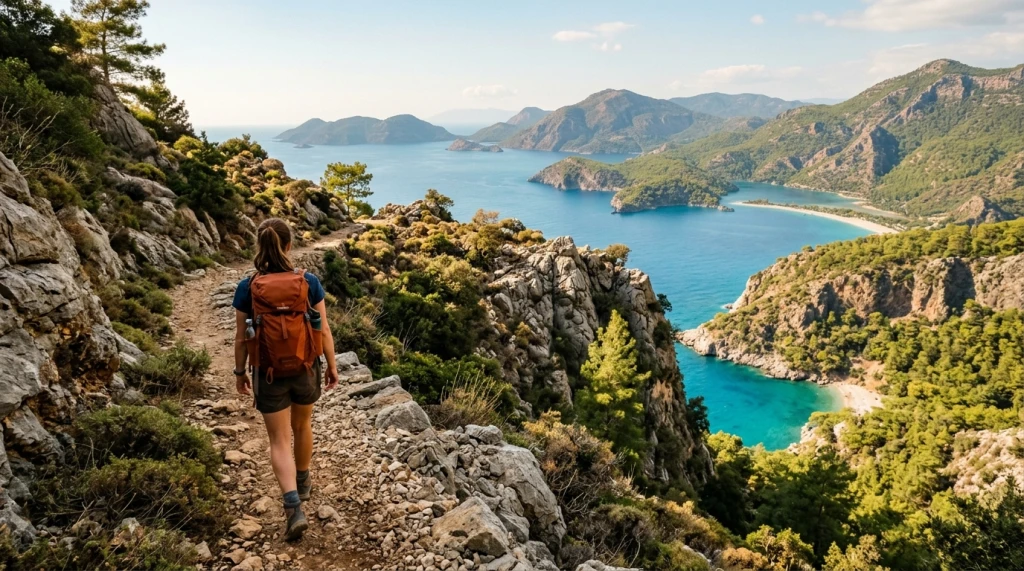
The Lycian Way is a marked long-distance hiking trail starting from Ovacık, just west of Fethiye, and extending to Geyikbayırı near Antalya, with a total length of approximately 540 kilometers. As Turkey's first and longest marked trail, this route was mapped in the early 2000s under the leadership of Kate Clow and has since become a preferred path for thousands of hikers from both within the country and around the world. The first question to clarify before visiting is: should you hike the entire route or only specific sections? The answer to this shapes both planning and expectations.
Where the Route Extends and How It Is Divided
The Lycian Way begins in the district of Fethiye in Muğla and follows the Mediterranean coast up to the central district of Antalya. Along the route, it passes through settlements such as Ölüdeniz, Kabak, Patara, Kalkan, Kaş, Kekova, Demre, Finike, and Olympos. While following the coastline, the path occasionally climbs ridges exceeding 1,000 meters; therefore, it is not a flat coastal walk, and significant elevation changes are involved.
The entire route corresponds to approximately 25-35 days of continuous hiking; this duration varies depending on an individual's average daily speed and rest preferences. Most visitors choose specific sections to create shorter programs. The route is divided into 29 stages, each averaging between 15-22 kilometers. Many sections can be planned with independent transport, allowing hikers to start and finish at points generally located along minibus or dolmuş (shared taxi) routes.
Which Section Suits Whom
The Ovacık–Kabak–Alınca line forms one of the steepest and most remote sections of the trail. This is where the sea views are most dramatic; however, accommodation options here are quite limited, and distances to water sources are long. It is not suitable for inexperienced hikers.
The Patara–Kalkan–Kaş line is a more logistically manageable section. The ancient city of Patara, sand dunes, and coastal villages intertwine in this area. Securing accommodation on or near the route is relatively easy, and access roads are better documented. For beginners, this stretch can be considered a warm-up section.
The Kaş–Kekova–Demre line stands out for its historical density. The sunken city of Simena, the Kekova islands, and St. Nicholas Church are located in this section. The hiking route overlaps with boat routes here, and local pensions can be found in various villages. It is suitable for those who wish to experience both nature and cultural elements simultaneously.
The Olympos–Çıralı line is one of the shortest and least demanding sections. Çıralı, the ancient city of Olympos, and the flames of Yanartaş are all present in this area. It is considered a reasonable starting point for families with children or those with limited hiking experience.
When to Go: Differences Between Seasons
The most suitable periods for the trail are April–May and October–November. In spring, vegetation refreshes, streams flow, and temperatures are favorable for hiking; daytime temperatures ranging from 15-22 degrees Celsius are ideal for long stages. Temperatures rise significantly towards the end of May.
During summer months, particularly July and August, temperatures in coastal areas can reach 38-40 degrees Celsius. Leaving very early in the morning and spending the afternoon in the shade becomes essential; this situation considerably reduces daily distances. Summer hiking requires experience and specialized equipment.
Winter, i.e., December–February, carries risks of snow and ice in some high-altitude sections of the route. Lower coastal sections can still be hiked in winter; however, some pensions and facilities may be closed out of season. The trail gradually reopens from the second half of March onwards.
Transportation: How to Reach the Start and End of the Route
Ovacık, the western starting point of the Lycian Way, is approximately 10 kilometers from Fethiye. Fethiye is accessible via Dalaman Airport; transfer and dolmuş options between the airport and Fethiye are available. Regular dolmuş services operate from Fethiye center to Ovacık.
Geyikbayırı, the eastern endpoint, is approximately 35 kilometers from Antalya. Antalya Airport is one of Turkey's busiest airports regarding both domestic and international connections. Transportation to Geyikbayırı from Antalya is possible by dolmuş or private vehicle.
For transportation to intermediate regions along the route, towns like Kaş, Kalkan, and Demre serve as central hubs. Investigating regular dolmuş schedules between these towns beforehand is crucial, especially outside the peak season; while morning and evening departures are usually available, intervals during midday may be longer.
Accommodation: What to Expect Along the Trail
Along the route, there are village pensions, camping areas, and boutique accommodation options. Small settlements like Kabak, Gey, and Bel have pensions open year-round, but capacity is limited; booking in advance during spring and autumn is advisable. In some stages, settlements along the path are very sparse; for these sections, carrying a tent or planning daily distances according to nearby towns is necessary.
Water becomes a critical resource, especially from early summer onwards. Although marked fountain and source points are shown on maps, some sources may dry up in midsummer. It is necessary to obtain current information before setting out and to hike with sufficient water capacity. Regarding food, shopping opportunities outside intermediate towns are very limited; starting a stage with adequate supplies forms the basis of planning.
Equipment and Preparation: What to Pay Attention To
The Lycian Way is not a standard city walk. Due to steep descents/ascent, loose stone terrain, and long stretches, ankle-supporting hiking boots are required; attempting long stages with sneakers increases the risk of joint and ankle injuries.
Kate Clow's paper guide remains the primary reference for route maps. Mobile applications are useful for tracking the route; however, since battery life and internet connectivity cannot be guaranteed, carrying a spare charger and downloading maps offline is recommended.
Some sections of the trail pass through common areas used by goat herds; in this route intertwined with wide living spaces, fundamental rules include not lighting fires, not leaving trash, and staying on marked paths. Lighting campfires in shrubland areas is legally prohibited due to fire risk.
Practical Planning Summary
- Duration: 3-5 days are sufficient for a single section, 7-14 days for multiple sections; plan 25-35 days to hike the entire way.
- Best season: April-May and October-November; July-August is challenging due to heat.
- Transport: Use Dalaman Airport for the western start at Ovacık, and Antalya Airport for the eastern end at Geyikbayırı.
- Accommodation: Pensions exist in villages and towns like Kabak, Gey, and Kaş; make reservations in advance during spring-autumn seasons.
- Water and supplies: Obtain them in intermediate towns; research the current status of source points along the trail beforehand.
- Equipment: Ankle-supporting hiking boots are mandatory; download maps offline and carry a spare charger.
- Safety: Some parts are remote and steep; if hiking alone, share your route with someone knowledgeable and make an emergency communication plan.
After completing your preparations, you can also look into programs that can be combined with the Lycian coast among domestic tour options covering different regions of Turkey.
What to Consider When Making Your Decision
When planning on the Lycian Way, first clarify your physical fitness level and available time. After determining which section you will hike, investigate transportation to the start and end points of that section; gaps in dolmuş schedules can sometimes necessitate an overnight stay. Choosing the right season directly affects comfort and safety more than the trail itself. Additionally, verifying water and accommodation sources in advance reduces surprises on the road; seasonal changes along the Mediterranean coast happen quickly, and some facilities may not yet be open in early April or may have already closed by late November.